
An event hand-out is rarely one clean line. It is a file of several tracks that run over the same ground, some of them in opposite directions, with a few waypoints the organizers dropped in. The hard route we tested with is nine legs and about 186 miles, plus two bail-out tracks. Ride it with a map that shows every track at once and, at a junction where three of them meet, you spend a minute working out which line is yours.
Life Lever Moto holds the whole route instead of one leg at a time, and shows what is next from wherever you are on it.
Load it once
Import the hand-out the way you import any GPX file. Moto proposes the route for you: it chains the tracks in file order, checks that each leg starts close to where the one before it ended, and leaves out a track that fits nowhere, which is what happens to a bail-out. A join report tells you where one leg ends and the next begins, and flags a gap. You can reorder the legs, flip one’s direction, add one back, or take one out.
Your file is not changed. The route is a view of it, so you can undo any of it.
Switch on Follow
Following is a switch, and it is off until you turn it on. With it on, the route moves along as you ride, and it does it in a way that survives overlapping tracks:
- It only ever considers two legs: the one you are on and the next. A stretch that two legs share cannot pull you onto the wrong one.
- It changes leg after the next leg alone has matched for about a quarter mile, in the direction it is drawn. No change on one stray fix.
- It tells you the truth when you leave the line. If you are off the route, nothing moves and the bar says so, with a button to pick your leg or show the whole route. A lunch detour or a skipped spur is picked up again when you rejoin.
- A relaunch finds your place. Close the app or lose the phone’s power and it reads your position on the route back.
What you see
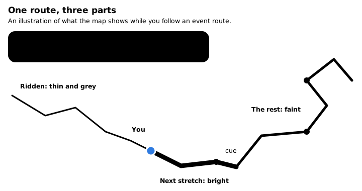
The route is drawn in three parts: what you have ridden, thin and grey (or hidden, if you ask), the bright stretch just ahead of you, and the rest, faint. At the top, a bar names the next cue and how far away it is. A cue is a waypoint from the hand-out within about 200 feet of the line, such as “Take 2N71” or “Right fork in 0.4 mi”, or the start of the next leg: “Stay on HW-1, HW-2 starts in 21.4 mi.” If the file has no waypoints, the leg starts still give you cues.
The turn word, left, right, straight, turn around, comes from the shape of the line itself, not from the compass. A phone on a handlebar mount sitting next to an engine does not always know which way is north, and the cue stays right when the map is pointed wrong.
You can have the cues spoken as well. That switch is off by default. The words go out through the phone’s audio, so a paired headset hears them.
It works on the trail
The route, the position pointer and the cues all run from the file on your phone. No signal needed, and no map downloaded needed either: with no map behind it, the route is still drawn.
What it is not
This is not turn-by-turn navigation that plans a route for you. The trail map does not compute routes, and the cues are the ones the organizers put in the file, plus the legs. For the road to the trailhead, street mode gives street directions with traffic and spoken guidance.
Where it stands
We have replayed a recording of a real hard-route ride, 4,621 GPS points over a day, through the follower. It changed legs at all eight joins, in order, and nowhere else, including through a 2.8 mile lunch detour. Made-up rides built from the hand-out, a bail-out, a leg ridden out and back, a skipped leg, all end up off route and never on a wrong leg. We have also watched it on the simulator.
Moto is an iPhone app in private beta. Join the beta, or read about everything Moto does.